


Entre deux Monts

Mangold
User
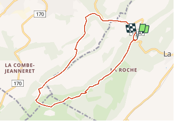

Length
8.6 km

Max alt
1300 m

Uphill gradient
338 m
Km-Effort
13.1 km

Min alt
1054 m

Downhill gradient
338 m
Boucle
Yes
Creation date :
2014-12-10 00:00:00.0
Updated on :
2014-12-10 00:00:00.0
--
Difficulty : Unknown

FREE GPS app for hiking
 SityTrail
IGN / Geographical institutes
SityTrail Plus
The world is yours!
About
Trail Other activity of 8.6 km to be discovered at Neuchâtel, Unknown, La Sagne. This trail is proposed by Mangold.
Positioning
Country:
Switzerland
Region :
Neuchâtel
Department/Province :
Unknown
Municipality :
La Sagne
Location:
Unknown
Start:(Dec)
Start:(UTM)
331635 ; 5212208 (32T) N.
Comments